WA WAnderings

Pressing on to the Nullarbor Plain next morning and soon encountering Australia’s longest straight stretch of road.

Snip 34.JPGSnip 35.JPG

The Caiguna Blowhole is 50m off the highway just W of Caiguna.

Snip 36.JPG

There are many caves on the Nullarbor.

Snip 37.JPG

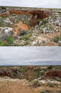
The most famous is the more than 6km long coughlebiddy Cave in the Nuytsland Nature Reserve (coughlebiddy, Western Australia - Wikipedia). The cave is closed and there seems to be little encouragement to detour off the highway to even see it from above, as there is no signpost, although once there the information board is of high quality.

It is most definitely not a cave for amateurs to mess around in.

Snip 38.JPGSnip 39.JPGSnip 40.JPGSnip 41.JPGSnip 42.JPG
 
Moving on to coughlebiddy Roadhouse to refuel and introduce myself to Samantha and Bruce, the rescued wedgetail eagles.

Snip 43.JPGSnip 44.JPG

About 15 clicks E of the roadhouse is the turn to the Eyre Bird Observatory. Camping is not possible there, but day visitors are welcome. It is possible, by advance reservation, to stay on a full board basis for $105/night (Eyre Bird Observatory - BirdLife Australia).

I had not made such an arrangement; in any event, they were in the process of caretaker changeover and were not taking bookings last week.

Snip 45.JPG

Air-down point at the top of the scarp, about 20km in from the highway on a good dirt road. The last 10 clicks are firstly a crawl down the steep limestone scarp, then through sand on a single-lane track. Not very testing, but definitely not for anything but full-size fourbys.

Snip 46.JPGSnip 47.JPGSnip 48.JPGSnip 49.JPG
 

Attachments

  • Snip 42.JPG
    Snip 42.JPG
    128.9 KB · Views: 0
The Eyre Bird Observatory is the functional part of the restored Eyre Telegraph Station that operated from 1897-1927. After decaying for 50 years, it was restored and became the bird observatory and telegraph museum in 1977 (Eyre Telegraph Station - Wikipedia).

Snip 50.JPGSnip 52.JPGSnip 53.JPGSnip 54.JPGSnip 55.JPGSnip 56.JPG

The outside support pole for the telegraph wires and the bridge on the roof eaves through which wires passed into the station.

Snip 57.JPG

Some telegraph pole artefacts outside made it clearer how the line was built. The slightly tapered base (bottom of rack) had a spear-like tip. Presumably most were hammered into the sandy ground, negating the need for more logistically demanding concrete foundations. Poles were then apparently sweated into the tapered base, which themselves could be stacked for extra height.

Snip 58.JPG

Snip 59.JPG
 
The Frequent Flyer Concierge team takes the hard work out of finding reward seat availability. Using their expert knowledge and specialised tools, they'll help you book a great trip that maximises the value for your points.

AFF Supporters can remove this and all advertisements

WA has a long-running biosecurity program to prevent the starling becoming established in the state. One of many monitoring stations operates at the observatory (Surveillance efforts ramp up for starlings in State’s south).

Three lure starlings are confined in a cage within a larger trap cage that had a one-way entry at the top. The lure birds were very nervous and hid in the roosting box when I approached the trap.

Snip 60.JPGSnip 61.JPG

Then to the beach.

Snip 62.JPG

Not quite enough momentum coming out to clear the very fine, light sand of the first dune. Quickly bottomed out.

A shovel job – but where is PJM when she is needed?!

Correction. Make that a shovel and MaxTrax job.

Dig out from under the axles and behind each wheel, MaxTrax behind the rear wheels, back up the length of the MaxTrax, place them in front and then power straight out.

Snip 63.JPG

The first time using the sand shovel and MaxTrax in anger. Too easy.

I then made my way out, aired up and started heading W on Eyre Highway.

There are two Main Roads 24h camp stops on the long straight and I reached the westerly one around sunset, for a convenient stop. Some friendly pied butcher birds and magpies came visiting.

Snip 64.JPGSnip 65.JPGSnip 66.JPG

Emergency airstrip on the highway not far E of Balladonia Roadhouse.

Snip 67.JPG
 
My initial plan was to head back to Balladonia Roadhouse, refuel and then take the Balladonia track S to Cape Arid NP. I had heard that it was rough in parts and also that was closed, although reputedly that there was only a road closed sign at the N end, and that some people had been going through, at least from the S.

The young overseas backpacker behind the counter at Balladonia Roadhouse asserted that it was definitely closed, but I was a little sceptical. Rather than defy the rather old looking sign, however, I opted to head straight into Norseman, then S towards Esperance before peeling off SW near Salmon Gums, to make Fitzgerald River NP my target destination.

I was at Fitzerald River NP last year in that episode of WAnderings (see post #77) but could not access the 4WD tracks owing to their closure after fires and the well-publicised firebomber crash. Surely the fourby tracks would be open this year...

Snip 68.JPGSnip 69.JPG

The aftermath of last year’s fire in the park. Mostly to the E of Hamersley Drive. Pics are dark, but the vegetation to the left is green; that to the right burnt. The destruction got worse further along.

The gate at the end of the bitumen that was closed last year was, as expected, now open.

Snip 70.JPGSnip 71.JPG

Turn 180deg.

Snip 72.JPG

Royal hakea (Hakea victoria) is always mesmerising.

Snip 73.JPGSnip 74.JPGSnip 75.JPGSnip 76.JPG
 
We did a similar run last September but added a leg up to Qld for a quick teaching job. It's been years since I have done the Nullabor but it's a good run these days. Would have liked a bit extra time but such is life. We also went and came back on the back roads and up through Salmon gums.
 
As reported from post #65 here: B737 Waterbomber crashes in south of W.A. Both pilots said to be not seriously injured but in hospital., I scoped out the firebomber crash site, a short distance along the 4WD track to Quoin Head and Whalebone Beach.

Snip 77.JPG

News report image immediately after the crash.

Snip 78.JPG

Google Earth image clearly showing the SSE impact path and where the aircraft came to rest at the 4WD track. It’s obvious why I couldn’t get anywhere near it just a few weeks after the crash last year. The crash path is on a gentle downhill slope.

The large L-shaped cleared section was a puzzle at ground level but from the satellite imagery it seems obvious that it was bulldozed as a firebreak or for other purposes during the wreckage recovery and cleanup operations.

Snip 79.JPG

On the ground.

Facing SW and the final resting spot on the S side of the 4WD track.

Snip 80.JPG

The crash path on the N side of the 4WD track and an indication of the maybe 15deg slope down to the left (S), the sandy substrate and the shrubby heathland vegetation about 3m high. The taller eucalypts extend to about 5m high but are scattered and spindly. Those pilots were very lucky to have such benign terrain in a fire zone…

Snip 81.JPG

The nearby bulldozed strip that was mysterious until Google Earth provided the likely explanation.

Snip 82.JPGSnip 83.JPG
 
The track down to the beach and inlet was steep and a bit slippery and gnarly.

Snip 93.JPGSnip 94.JPGSnip 95.JPG

I made my way back out, bypassing the turn to Whalebone Beach as it was getting late, and headed to Hamersley Inlet to look for a camp site.

Snip 96.JPGSnip 97.JPG

The main camping area was quiet, probably about a third full. Let me check a bit further afield before making a choice.

Snip 98.JPG

There was one other camping area, a small secondary area devoid of people, and right on the inlet. Sweet! I claimed a spot next to a table and I could take an open-air shower under an adjacent tree without risking arrest. A tranquil night and glorious peaceful morning.

Snip 99.JPGSnip 100.JPGSnip 101.JPG
 
Then back to the 4WD track to tackle the Whalebone Beach section. This was much more challenging. It became very narrow and winding, which leaves me twitchy about who might be coming the other way and how to get past. Also gnarly rocky spots and plenty of soft sand nearing the beach. Slower going than to Quoin Head.

Snip 102.JPGSnip 103.JPGSnip 104.JPGSnip 105.JPGSnip 106.JPGSnip 107.JPGSnip 108.JPGSnip 109.JPG
 
Snip 110.JPGSnip 111.JPGSnip 112.JPG

Back to the main and easily accessible E side of tranquil Hamersley Inlet near the camping area.

Snip 113.JPGSnip 114.JPG

Then a short drive on a very narrow sandy track towards Hamersley Beach. I didn’t bother tackling the dunes as it didn’t seem to go anywhere in particular and I wanted to start the 6h drive home.

Snip 115.JPGSnip 116.JPG

Then I bee-lined for home.

An afternoon pitstop at Williams, about 2h out of Perth on Albany Highway, to find that a statue by Jordan Sprigg had been installed at the rest stop. His work is exceptional in my view (Full Gallery of Jordan Sprigg Sculptures — Jordan Sprigg Sculptures).

Snip 117.JPGSnip 118.JPG

And that was it for an excellent few days away.

I think Cape Arid NP is on the WAndering agenda this time next year.
 
Sponsored Post

Struggling to use your Frequent Flyer Points?

Frequent Flyer Concierge takes the hard work out of finding award availability and redeeming your frequent flyer or credit card points for flights.

Using their expert knowledge and specialised tools, the Frequent Flyer Concierge team at Frequent Flyer Concierge will help you book a great trip that maximises the value for your points.

Back
Top