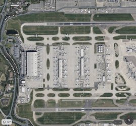
A nearly vacant LHR?

Status
Not open for further replies.

Scarlett

Established Member
Joined
Jun 27, 2011
Posts
1,257
Qantas
LT Gold
Virgin
Platinum
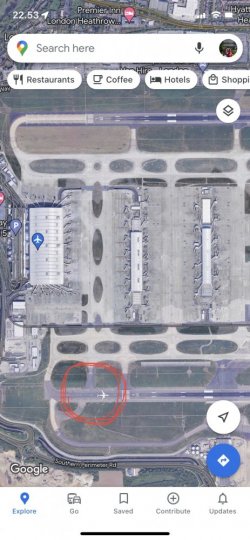
Someone else needs to check this, but looking at the current google maps image for LHR, there appears to be not a single aircraft at a gate! At one of the worlds largest airports!

There is however a QF 787 looking like it’s about to depart on 09R and a Saudi 777 coming off that RWY heading for T4, but otherwise, the airport looks empty.

Now, if you zoom in on a couple of the terminals there appears to be artefacts of aircraft at the gates, or maybe they’ve been photoshopped over. What’s going on? Was someone really bored at the googleplex one day?
1650557112455.jpeg
 
There were plenty of aircraft at gates middle of the day last Tuesday when I flew to BER. T5 wasn’t manic but looked pretty much business as usual with Spring term break/Easter.
 
This is Google removing these, I've seen other airports too on Google with this.

Not sure why they are doing this though!
 
Google earth (as distinct from google maps) actually shows the dates and I don't know why Maps doesn't; "imagery date 4/10/20" is written on the photo when I search LHR through Google earth. But, it's a different photo in google earth, still almost deserted of course given the date (maybe everyone was at the party at No. 10) but no aircraft lined up on rwy 09R. Strange.
 
Zooming in on Maps, the aircraft lined up on rwy 09R is a Qantas twin. At LHR?
 
I believe this is deliberate. I have read somewhere that they will overlay many images and select the one without aircraft.

Why? - I'm not sure.

Apparently, when images from different timestamps are stitched you can get some random results with an aircraft at a gate being a specific airline on one side, and then another airline on the other.
 
The Frequent Flyer Concierge team takes the hard work out of finding reward seat availability. Using their expert knowledge and specialised tools, they'll help you book a great trip that maximises the value for your points.

AFF Supporters can remove this and all advertisements

I think that whenever looking at maps with LHR in them, I’ve not been using the aerial photo view … because LHR feels much bigger to drive around than the size of the aircraft in that photo would indicate!

Google earth (as distinct from google maps) actually shows the dates and I don't know why Maps doesn't; "imagery date 4/10/20" is written on the photo when I search LHR through Google earth. But, it's a different photo in google earth, still almost deserted of course given the date (maybe everyone was at the party at No. 10) but no aircraft lined up on rwy 09R. Strange.
I’ve seen the date of the photo in Google Maps before, but it looks different depending on how you look at it (browser vs ‘phone app vs tablet app for example) and I can’t recall which of them I’d seen the date on.
 
I believe this is deliberate. I have read somewhere that they will overlay many images and select the one without aircraft.

Why? - I'm not sure.

Apparently, when images from different timestamps are stitched you can get some random results with an aircraft at a gate being a specific airline on one side, and then another airline on the other.
I wonder why they go to the trouble of overlaying multiple images to remove aircraft from an airport… sort of the natural habitat!!!
In this example (LHR) it’s almost as though they have deliberately tried to remove some of the aircraft or copy concrete over the top. Strange.

I’ve seen plenty of those kind of weird google maps examples of half houses, or snow on one side of the street but a different season on the other. Always interesting to see the contrasts.
 
Status
Not open for further replies.
Back
Top