Ask The Pilot

  • Thread starter Thread starter NM
  • Start date Start date
  • Featured
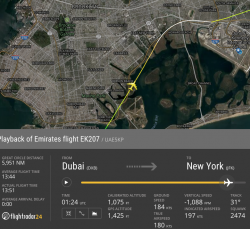
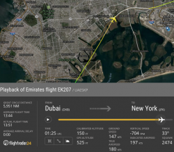
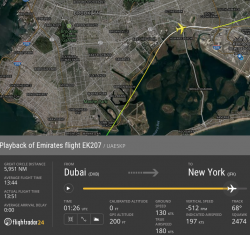
Have a look at this Flightradar24.com - Live flight tracker! If the link doesn't work correctly, look at the flight on 4/12/17.

The pertinent time is 01:25Z.

You can draw your own conclusions.

Looks very similar to Moscow, does EK have a culture problem that is putting it into the same ‘jb747 fly category’ as Air France and Air Asia? Their near misses seem to be stacking up.
 
jb, quick question, which I have tried to guess but not sure. Conflicting info. On a 747 flight SCL-SYD, and a 737 SYD-BNE, how many staff will be aboard? I fly these Christmas Day and want to make a small gift to all.
 
jb, quick question, which I have tried to guess but not sure. Conflicting info. On a 747 flight SCL-SYD, and a 737 SYD-BNE, how many staff will be aboard? I fly these Christmas Day and want to make a small gift to all.

I think the 737 will be 2+4, and the 747 3+14.
 
Looks very similar to Moscow, does EK have a culture problem that is putting it into the same ‘jb747 fly category’ as Air France and Air Asia? Their near misses seem to be stacking up.

I don't know the reasons, and I doubt that we'll ever hear a straight answer. But the Moscow, and now New York approaches are pretty amazing. Add the 777 'go around', and I'll probably lump the Fly Dubai accident in there as well.

The rumour machine (and it's just that, I have no way to verify this) is that they have 380s parked because they cannot crew them, and those crews that they do have are being burnt out. I know they've had very severe losses...the sandpit has lost whatever shine it ever had. Certainly all of these incidents could be caused by fatigue.
 
Have a look at this Flightradar24.com - Live flight tracker! If the link doesn't work correctly, look at the flight on 4/12/17.

The pertinent time is 01:25Z.

You can draw your own conclusions.


Date a/craft Location last three numbers ALT SPD DIR
2017-12-05T01:25:03Z UAE5KP 40.62973,-73.880798 700 169 29
2017-12-05T01:25:10Z UAE5KP 40.633865,-73.877754 600 165 29
2017-12-05T01:25:16Z UAE5KP 40.63773,-73.874878 525 161 29
2017-12-05T01:25:22Z UAE5KP 40.641407,-73.872131 425 158 29
2017-12-05T01:25:28Z UAE5KP 40.645432,-73.869202 350 154 29
2017-12-05T01:25:34Z UAE5KP 40.649139,-73.866455 250 150 29
2017-12-05T01:25:40Z UAE5KP 40.652767,-73.863518 150 147 33
2017-12-05T01:25:46Z UAE5KP 40.655411,-73.860962 100 144 38
2017-12-05T01:25:54Z UAE5KP 40.659531,-73.855469 0 137 50
2017-12-05T01:26:00Z UAE5KP 40.661518,-73.851906 0 135 56
2017-12-05T01:26:06Z UAE5KP 40.66338,-73.847664 0 132 62
2017-12-05T01:26:12Z UAE5KP 40.664963,-73.842979 0 130 68
2017-12-05T01:26:18Z UAE5KP 40.665985,-73.838623 0 130 73
2017-12-05T01:26:24Z UAE5KP 40.666763,-73.833374 0 138 81
2017-12-05T01:26:30Z UAE5KP 40.667149,-73.82856 150 134 87
2017-12-05T01:26:55Z UAE5KP 40.665619,-73.808594 1075 125 95
2017-12-05T01:27:16Z UAE5KP 40.668964,-73.791794 1550 156 70
2017-12-05T01:27:23Z UAE5KP 40.670425,-73.786255 1575 177 71

This is a short extract from the csv file from the FR24 data....VERY scary....The altitude a was so low, the feed dropped out, and the SPD did not leave much room for comfort while the aircraft was in a turn by the look of the direction....

JB, I was going to ask you some questions about this...but thought, best left alone....
I couldn’t get FR24 to display this flight so thanks for posting this data. I’m going to ask some questions to clarify my understanding of these numbers. As always JB can decline to answer.

1. Is it possible these numbers are wrong?
2. From the first six lines of data it appears the aircraft was flying 029 degrees. Correct?
3. If yes, is 029 degrees correct for the RWY being attempted? In other words, were they good down to 150ft?
4. Where the altitude displays as 0 for 30 seconds, would the aircraft actually have been on the ground, or just to low to send ADS-B data?
5. At the speeds recorded, how far do you estimate the aircraft would have travelled in that 30 seconds from 1:25:54Z?
6. Any chance you could post a screenshot of the track if you can still pull it up on FR24 please?
 
The three images were taken at:
1) the spot at which they should have been at exactly 1,500' on the Carnarsie VOR/GPS to runway 13 L/R
2) the point at which they should be at 800', and from which they have 3.6 NM to run to 13L
3) a point close in, just before ATC told them they were too low, at which they should have been at about 600'

The idea with this approach is that you descend to the minima, and then you have to maintain level until you intercept the normal vertical path. It's VISUAL approach after the minima. The aircraft will not automatically fly it after the missed approach point (that 800' point).
 

Attachments

  • Screen Shot 2017-12-17 at 09.17.38.png
    Screen Shot 2017-12-17 at 09.17.38.png
    717.8 KB · Views: 91
  • Screen Shot 2017-12-17 at 09.17.11.png
    Screen Shot 2017-12-17 at 09.17.11.png
    667.6 KB · Views: 87
  • Screen Shot 2017-12-17 at 09.16.40.png
    Screen Shot 2017-12-17 at 09.16.40.png
    756.8 KB · Views: 85
1. Is it possible these numbers are wrong?

There's some level of error in the data, but given their final approach and landing numbers look reasonable, then not a great deal. ATC also told them they were too low, so it's not an explanation.

2. From the first six lines of data it appears the aircraft was flying 029 degrees. Correct?
3. If yes, is 029 degrees correct for the RWY being attempted? In other words, were they good down to 150ft?

The approach is an offset approach. At the missed approach point, your track will be 041º, and you have to turn to 135º to align with the runway...which is why it's a visual manoeuvre.

4. Where the altitude displays as 0 for 30 seconds, would the aircraft actually have been on the ground, or just to low to send ADS-B data?

If it was on the ground, you'd be reading it in the papers. It was very low though...probably below 200'.

5. At the speeds recorded, how far do you estimate the aircraft would have travelled in that 30 seconds from 1:25:54Z?

Ground speed is on the images above. But he's doing about 130 knot g/s, so a little over a nautical mile.
 
EXCLUSIVE OFFER - Offer expires: 20 Feb 2025

- Earn up to 200,000 bonus Velocity Points*
- Enjoy unlimited complimentary access to Priority Pass lounges worldwide
- Earn up to 3 Citi reward Points per dollar uncapped

*Terms And Conditions Apply

AFF Supporters can remove this and all advertisements

Is that the responsibility of the pilot not flying the aircraft to check the altitude? Or both pilots should monitor the speed, position and altitude on approach? Is this different in bad weather versus beautiful sunny day?
 
Is that the responsibility of the pilot not flying the aircraft to check the altitude? Or both pilots should monitor the speed, position and altitude on approach?

The exact plan of attack should have been briefed before the approach. The pilot flying is responsible for keeping the aircraft in the correct 3d position and energy state. The monitoring pilot should only need to call out any deviation.

Is this different in bad weather versus beautiful sunny day?

It's easier on a nice sunny day, but in all cases, the actual approach after the missed approach point has to be flown visually. If you don't have the correct visual reference at minima, then you go around at that point. The 3d track is identical, no matter what the conditions.

Just like the Moscow approach, this is so bad that you wonder how it's even possible.
 
Would the aircraft give any ground proximity warning if at 200ft when still too far from the runway threshold?
 
The rumour machine (and it's just that, I have no way to verify this) is that they have 380s parked because they cannot crew them, and those crews that they do have are being burnt out

I think there is a very negative anti-ME sentiment amongst some forums, driven by the US group in particular and these rumours have persisted for some time
(Much like the anti-Jetstar/JetConnect on some local forums).

I think on airliners.net someone did an analysis of fleet utilisation by flight record and average hours of A380 utilisation has actually increased compare to a few years ago.
 
Would the aircraft give any ground proximity warning if at 200ft when still too far from the runway threshold?

Not really. The GPWS tends to be looking for unsafe terrain closure rate, or descent rate. As long as the gear and flaps are in the correct configuration, it assumes you'll actually land on a runway. One would hope you'd notice when the rad alt starts counting down for the flare...
 
Seasons greetings all.
JB, on the 8/12 I had the pleasure of flying BNE-YVR with Air Canada. Lovely albeit lengthy journey to a gorgeous destination. Noticed upon arrival that we were still well and truly among dense cloud/fog with minimal vis when the mains touched the runway. Spoke to the Capt who confirmed my suspicions that it was an AutoLand. I read that QF75 on 14/12 diverted to SEA due to fog and was curious as to why they had to divert as opposed to executing an AutoLand? Obviosuly im unsure of the conditions they were faced with, but I thought it was pretty darned foggy when we arrived.
Thanks for your time!
 
Even if you are equipped with Cat II or III you cannot continue to an airport that requires such a landing unless you have an alternate. Whilst the 14th was foggy all day, the 13th wasn't so it's quite possible that it wasn't on the forecast when they left Sydney. On top of that, there are many things that can take away the ability to carry out a low vis landing. Sometimes a relatively minor failure, that has no real effect on the aircraft in flight, will give you 'no auto land'. If I recall correctly, the FO's radalt was one such item.
 
Okay thanks for that. I know that operational safety is imperative but it'd be such a PITA for all involved having to divert to and airfield so close, yet so far, especially after such a long trip.
On a side note, spent a few days in Seattle and visited the Boeing Factory in Everett which was brilliant. Didn't see any of the QF Dreamliners though.
 
JB, today a sponsored link on Facebook is from Qantas and promoting a game for kids to play. It's about the Dreamliner and its inaugural flight MEL-LAX.
I thought that the A380s were doing this route and the B787s were doing the PER-LHR ones.

If the 787s are going to be tootling across the Pacific, what will the 380s end up doing?
 
I thought that the A380s were doing this route and the B787s were doing the PER-LHR ones.

If the 787s are going to be tootling across the Pacific, what will the 380s end up doing?
The A380s are still doing MEL-LAX. QF93/94 is A380. QF95/96 is 787. Once PER-LHR starts, QF93 (A380) is a late morning (~11am) out of MEL while QF95 (787) will be an evening departure (~7pm).
The first 4 787s will rotate through LAX-MEL-PER-LHR.
 
Have a look at this Flightradar24.com - Live flight tracker! If the link doesn't work correctly, look at the flight on 4/12/17.

The pertinent time is 01:25Z.

You can draw your own conclusions.

Wow how crazy is this. Most likely below 200FT before final approach?

Were they planning to land on 13L?.
Did they go below minimum before final approach and then conducted a missed approach and repositioned for 22L?
 
Last edited:

Become an AFF member!

Join Australian Frequent Flyer (AFF) for free and unlock insider tips, exclusive deals, and global meetups with 65,000+ frequent flyers.

AFF members can also access our Frequent Flyer Training courses, and upgrade to Fast-track your way to expert traveller status and unlock even more exclusive discounts!

AFF forum abbreviations

Wondering about Y, J or any of the other abbreviations used on our forum?

Check out our guide to common AFF acronyms & abbreviations.
Back
Top