Ask The Pilot

  • Thread starter Thread starter NM
  • Start date Start date
  • Featured
Without getting into it was this the same incident where the personality of an individual was a contributing factor?

Yes, but my understanding is that it was very much misreported. As I understand it, the Captain wasn't the most popular, but he was correct in his assessment.
 
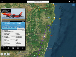
This afternoon’s JQ826 SYD-BNE appears to have decided BNK is a better option.

0A50E938-041E-4C73-8EC5-CDBB4F0868B0.png

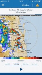
While it may not be weather related, this is the ground based weather radar at the time of diversion.

CB160D45-FD8A-42AB-8B94-F86827304A8F.jpeg

Plenty of other aircraft continued on to BNE from the south.

I realise pilots can only make decions based on the available information, and this crew might have seen an ugly picture at that point in time.

But I’m wondering how different the aircraft generated weather data is from type to type?

Do Boeing and Airbus have proprietary radars they use, or do both manufacturers buy/install the same?

Do some aircraft types provide more weather information than others?

Finally, assuming the diversion is weather related, why choose BNK which has limited company support compared to OOL, or returning to SYD? Half way seems to be no-man’s land and takes the aircraft out of service until weather improves.
 
This afternoon’s JQ826 SYD-BNE appears to have decided BNK is a better option.

While it may not be weather related, this is the ground based weather radar at the time of diversion.

Which is getting ugly, though it's quite a bit nastier now (a couple of hours later).

Plenty of other aircraft continued on to BNE from the south.

Which would make me suspicious that the diversion was not weather related.

I realise pilots can only make decisions based on the available information, and this crew might have seen an ugly picture at that point in time.

But I’m wondering how different the aircraft generated weather data is from type to type?

Do Boeing and Airbus have proprietary radars they use, or do both manufacturers buy/install the same?

Do some aircraft types provide more weather information than others?

There are multiple different models and makes of radar systems. They come from people like Honeywell. Perhaps perversely, many of us who used manually controlled radars look back longingly at them. The radar in the 380 generates a 3 dimensional database around the aircraft. Others aren't so flash, but all give sufficient information to avoid the nasties.

You're not likely to divert based on radar returns. As long as you could get to the airport without going through anything nasty, you'd be using the weather reports for your decisions.

Finally, assuming the diversion is weather related, why choose BNK which has limited company support compared to OOL, or returning to SYD? Half way seems to be no-man’s land and takes the aircraft out of service until weather improves.

It's an odd choice, and he hasn't held at all, which makes me suspect that it isn't weather related. Logic would have you carrying sufficient fuel to get well away from Brisbane....with back to Sydney being the 'best' choice.

Does Ballina see 320 ops normally? I'd have expected it to be in the domain of the regionals.
 
This afternoon’s JQ826 SYD-BNE appears to have decided BNK is a better option.

While it may not be weather related, this is the ground based weather radar at the time of diversion.

Plenty of other aircraft continued on to BNE from the south.

I realise pilots can only make decions based on the available information, and this crew might have seen an ugly picture at that point in time.

But I’m wondering how different the aircraft generated weather data is from type to type?

Do Boeing and Airbus have proprietary radars they use, or do both manufacturers buy/install the same?

Do some aircraft types provide more weather information than others?

Finally, assuming the diversion is weather related, why choose BNK which has limited company support compared to OOL, or returning to SYD? Half way seems to be no-man’s land and takes the aircraft out of service until weather improves.

There was a lot of holding going on. My guess is they were told to hold but didn’t have the required fuel to hold for that amount of time. BNK looked clear and so put it down there for a splash and dash.

We came in from HBA and got holding at TMW, then got vectored around the back towards AMB then into BNE. We carried enough fuel for about 1.5hrs of holding and only used up about 30mins of that so we were comfortable and were looking at CFS for our latest diversion airport.

Returning to SYD may not have been an option given their loads, I’m not sure of their max limits.
How long does a splas and dash typically take... especially at an airport like BNK which isn’t staffed all the time.

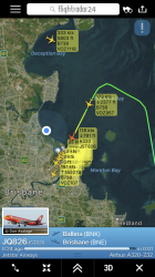
FWIW they’re just getting into BNE, a little more than 3hrs after the diversion.

2EE64A24-1F0B-4BDD-ADED-B32FF58F09F6.png
 
How long does a splas and dash typically take... especially at an airport like BNK which isn’t staffed all the time.

FWIW they’re just getting into BNE, a little more than 3hrs after the diversion.

Well like you’ve just seen there when you’re outside scheduled operations, it can take a loooooong time! Especially because the refuellers need to get to the airport and do their checks with the fuel. But when you’ve got no other options, just put the aircraft down and deal with the delay. Possibly would’ve been quicker to bus the pax up?
 
That storm yesterday afternoon was pretty nasty on the ground. I was out driving in it around 3-3:30pm and it was not good. It was a pretty much continuous line that would have gone over OOL as well as BNE. So I can see why they might have picked BNK instead of OOL. And I also assume there would have been a little air traffic congestion to contend with after the nasty stuff blew through. At least on the ground in the BNE area the rain and wind stopped fairly quickly after the big dark red radar blobs sailed on eastward.

Would ATC have given them some indication of the expected holding time based on the weather conditions and anticipated traffic congestion that would follow? Perhaps the total expected hold time was long enough for them to decide they may as well get onto the ground and wait rather than wait it out sight seeing over Grafton.
 
Would ATC have given them some indication of the expected holding time based on the weather conditions and anticipated traffic congestion that would follow? Perhaps the total expected hold time was long enough for them to decide they may as well get onto the ground and wait rather than wait it out sight seeing over Grafton.

The traffic yesterday was building up quickly over TMW, we were one of the first ones into the hold and ATC couldn't give us an estimated time of landing (we had enough to hold for 1.5hrs before diverting). After about 30mins once most of the weather cleared, traffic on min fuel (south of BNE) got to try an approach first. Once they were successful then we got given a routing over AMB for the ILS to 01 at max speed to keep the flow of traffic coming in.

We did hear of aircraft diverting north of BNE to ROK.

When there's a squall line of thunderstorms like that it'll almost always follow a NW/SE line and take out MCY/BNE/OOL at the same time.
 
Ah...the "splash and dash". That's one of those throw away lines, that refers to a particular type of diversion...which isn't applicable in about 90% of cases. Generally, it comes up on long flights (for instance LAX-MEL), where you are unable to carry the required fuel for Melbourne. You could press as far as possible, before admitting defeat and returning to Sydney, or (if really lucky) having the requirements disappear and continuing to destination. It's a game of odds...what is the likelihood of either outcome? If you consider the diversion option to be the most likely outcome, you could, early in the flight, increase the speed to the max. Fuel consumption won't be an issue, because you are making your destination Brisbane. Call ahead, get everyone ready to turn the aircraft around as quickly as possible.... You could be in, and out, in about 30-40 minutes. You will still be late in Melbourne, but way better than the return to Sydney option.

To be legal for a flight, you have to carry any fuel that is both normally carried, and any extra required by weather or NOTAMs. That may mean holding fuel, or diversion fuel. Companies go to great lengths to find ways of carrying as little as possible, whilst being legal. The trouble is that being legal, and carrying a sensible amount of fuel aren't often the same. In this case, a look at the weather would have most pilots loading both fuel for an alternate, and also for substantial holding. You just know that you'll be held even if you aren't directly affected by the weather....and you'll need to keep that alternate fuel in the tanks. But, company dispatchers will simply give you what is legal...and if you suddenly need 60 minutes on top of that, then too bad.
 
Flew the new Cathay A350-1000 on the CX662 BKK-HKG service. The flight took a NE track over Thailand, Laos an Vietnam then into the South China sea towards Hainan Island at FL370 (11,300m). As we approached Hainan Island we descended to FL351 (10,700m). After we passed over Hainan Island we then climbed back up the original FL370 (11,300m). Given Hainan Island is considered part of China is this height change simply the aircraft transitioning through China airspace and in doing so from ICAO altitude to China standard altitude? I could imagine things could get very confusing with the amount of traffic passing through that corridor.
 
Last edited:
Flew the new Cathay A350-1000 on the CX662 BKK-HKG service. The flight took a NE track over Thailand, Laos an Vietnam then into the South China sea towards Hainan Island at FL370 (11,300m). As we approached Hainan Island we descended to FL351 (10,700m). After we passed over Hainan Island we then climbed back up the original FL370 (11,300m). Given Hainan Island is considered part of China is this height change simply the aircraft transitioning through China airspace and in doing so from ICAO altitude to China standard altitude? I could imagine things could get very confusing with the amount of traffic passing through that corridor.

I don’t have access to my Jeppesen charts at the moment, but what you’ve said sounds correct. It certainly has the potential to cause issues, which is why the changeover is carefully handled. Most times that I’ve seen it, it was managed by either HK, or the mainland centre just to the north.
 
I don’t have access to my Jeppesen charts at the moment, but what you’ve said sounds correct. It certainly has the potential to cause issues, which is why the changeover is carefully handled. Most times that I’ve seen it, it was managed by either HK, or the mainland centre just to the north.

From memory QF29/30 (HKG-LHR-HKG) would have encountered a similar scenario tracking out of HKG into Chinese then Russian then European airspace. The current QF107/108 (SYD-PEK-SYD) and QF129/130 (SYD-PVG-SYD) are required to transition from ICAO to Chinese airspace and vice versa. Do the rules around RSVM still apply in Chinese / Russian airspace? Are their specific versions of TCAS that work in ICAO, Chinese and Russian airspace?
 
From memory QF29/30 (HKG-LHR-HKG) would have encountered a similar scenario tracking out of HKG into Chinese then Russian then European airspace. The current QF107/108 (SYD-PEK-SYD) and QF129/130 (SYD-PVG-SYD) are required to transition from ICAO to Chinese airspace and vice versa. Do the rules around RSVM still apply in Chinese / Russian airspace? Are their specific versions of TCAS that work in ICAO, Chinese and Russian airspace?

Quite correct. 29/30 saw it change a couple of times along the way. There were basically transition areas on the various tracks, where the controllers would sort it out. If I recall correctly, and it's quite a time since I've seen it, the controllers would put you at the correct level for the area you were entering....so you arrived in the new airspace at the correct level. The aircraft have the ability to show metric altitudes on the flight displays, although we still have to convert the settings we put into the MCP. The FMCs recognise the various different forms of altimetry.

An oddity perhaps, but the english measurements for height work better than the metric. 300 metres roughly equates to a 1,000', but it's simply easier to work in thousands than in multiples of 300. For this old codger anyway....

An aside perhaps, but the 29/30 was my favourite flight. The hardest sector was the one leaving Melbourne for HK. After that one, the others were easier on the body. The scenery along the way was pretty interesting.
 
An aside perhaps, but the 29/30 was my favourite flight. The hardest sector was the one leaving Melbourne for HK. After that one, the others were easier on the body. The scenery along the way was pretty interesting.

The timing of it changed a bit over the years didn’t it? If I recall one of the legs inbound to HK had it arriving very early in the morning. Perhaps 5am?
 
The timing of it changed a bit over the years didn’t it? If I recall one of the legs inbound to HK had it arriving very early in the morning. Perhaps 5am?

I only recall one version. Left Melbourne around midnight, and arrived early am in HK. Departed for London about 9am, for an all daylight flight, arriving around midday. Return was an early pm departure, arrived in HK early am again. Then daylight back to Melbourne.
 
Australia's highest-earning Velocity Frequent Flyer credit card: Offer expires: 21 Jan 2025
- Earn 60,000 bonus Velocity Points
- Get unlimited Virgin Australia Lounge access
- Enjoy a complimentary return Virgin Australia domestic flight each year

AFF Supporters can remove this and all advertisements

I only recall one version. Left Melbourne around midnight, and arrived early am in HK. Departed for London about 9am, for an all daylight flight, arriving around midday. Return was an early pm departure, arrived in HK early am again. Then daylight back to Melbourne.

In that same vain, what would be the most brutal flight for you? Something like a SIN to MEL with a dawn arrival?
 

Become an AFF member!

Join Australian Frequent Flyer (AFF) for free and unlock insider tips, exclusive deals, and global meetups with 65,000+ frequent flyers.

AFF members can also access our Frequent Flyer Training courses, and upgrade to Fast-track your way to expert traveller status and unlock even more exclusive discounts!

AFF forum abbreviations

Wondering about Y, J or any of the other abbreviations used on our forum?

Check out our guide to common AFF acronyms & abbreviations.
Back
Top