I was at Fitzgerald River NP (
Fitzgerald River National Park,
Fitzgerald River National Park » Fitzgerald Coast) early last week, camping at Four Mile Campground, which is on the east side, near the area of the fire and where the aircraft crashed.
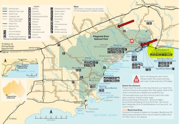
As I previously noted, FR NP is not remote, but it is inaccessible, particularly the central area. It is an internationally recognised Biosphere Reserve because of its extremely rich biodiversity. Think World Heritage. A key concern is spread of the ‘Dieback’ root pathogen fungus. Hence there are almost no roads or tracks within the park, which is really divided into separated E and W sections. The only way to go between them is to drive right around.
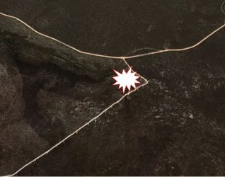
The map shows that, and the red arrows show where Hamersley Drive was closed. Hamersley Drive is a good 2WD dirt road between the arrows. I have marked the crash site. A 4WD only track runs SW from near there to two coastal spots, Quoin Head and Whalebone Beach.
As can be seen, the crash was very close to Hamersley Drive and that 4WD track. As might be expected, road access to the crash area was closed when I was there. On the S side, gates where Hamersley Drive changes from bitumen to dirt were firmly locked.
What piqued my attention as I drove out from Hopetoun was the digital trailer sign stating that roads within the park were closed because of “dieback spread”. Clearly a distracting fib at this warm and dry time of the year when it’s the most likely time they would be open. (There were no road closed signs at the N entry to the W side of the park when I subsequently drove past.)
I’m not an aviator; my interest from that perspective is purely vicarious. I am, however, a biologist and there are several things from a biological perspective that intrigued me about this incident.
As previously posted, I felt it important to clarify the type of vegetation in the area and the consequent nature of the fire. It was not, and could not be, a raging crown fire in tall, dense Eucalypt forest.
That seemed to be an assumption many people made – likely because that is the typical scenario where these large water bombers are seen in action. To that extent, it was therefore not unreasonable – but an assumption without foundation and far from accurate, nevertheless.
Juan Browne (
) questioned why the Australian authorities were using such a firebombing procedure in ‘scrubland’. The context clearly being that it’s not worth risking your life for that.
I must say, being familiar with the landscape of Fitzgerald River NP, that my immediate thought when I first saw the report of the crash was that using a B737 there seemed like overkill. Not because of not valuing the biome, but because of the relatively low-intensity fire and not totally inaccessible terrain (a solid old 70 series Landcruiser with a steel bullbar could push through the scrub.)
On the face of it, it seemed a reasonable thing to question, when Air Tractors are widely used for firefighting from local strips across SW WA. (From FR24, some were operating out of nearby Ravensthorpe to that fire).
However, there may be particular biological and conservation factors at play that had the authorities scrambling to endeavour to stop the fire - moving SE to NW - in its tracks that caused them to call in the large tanker. The fire was clearly not a raging inferno critically threatening life and (man-made) property.
Perhaps they were wanting to prevent it jumping Hamersley Drive or the 4WD track into the large wilderness in the central N of the park.
Perhaps they were trying to avoid as much as possible vehicle movement into undisturbed terrain because of Dieback spread concerns (even though it was at one of the few points for intersecting tracks in the E side of the park.)
Perhaps there was the threat of it getting into some localised pocket of sensitive terrain (borne out by the very cagey resident ranger intimating to me that there was a ridgeline, or some localised different topography, that they wanted to keep it out of.) Again, probably also related to minimising soil disturbance because of Dieback spread concerns. He did say all vehicles involved were washed down.
All that is purely speculation on my part, but consistent with the very high biological and conservation value attached to the park.
In fairness, ground wet by firefighting water and disturbed by firefighting vehicle movement could also partly be a reason why they were claiming ‘Dieback spread concerns’ on the road closure signs. But the main reason surely had to be keeping inquisitive people away from the crash remains, given its close proximity to Hamersley Drive and the 4WD track.
As I said, the ranger was very circumspect and couldn’t be drawn on very much at all. He did say that salvage work and soil sampling (I guess for hazardous contaminants) was in progress. He also said that it was the first time the B737 tanker had gone to FR NP.
When I said, “The pilots were very lucky.”, his response was “Ten feet higher and they would have been OK; two feet lower and it would have been a disaster.” Make of that what you will, but he definitely did not seem given to shooting off his mouth.
Topo map indicates some slight variation in terrain at the site.
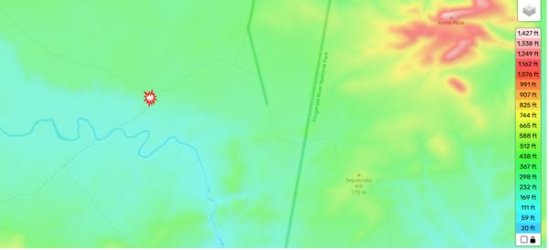
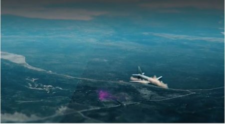
Snip from the TV report simulation in Post #37, but it is clearly not Hamersley Drive that it ended up at, rather the 4WD track. The impact location was actually in as an accessible area of the park as could be hoped.
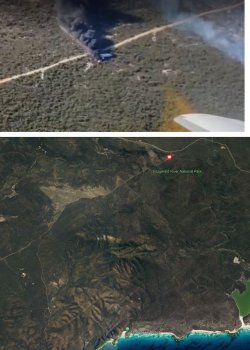
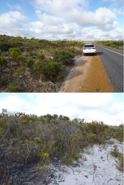
Here’s what the vegetation and soil is like not far S of the crash site. There is a smattering of taller (3-5m) spindly eucalypts in parts (see in the background of the top pic), but no large trees.
Going to some of the aviation matters and comments today, it was interesting that Juan Browne’s subsequent video to the Fireliner crash was about the final report of a crash in Canada of a ‘bird dog’ aircraft (
).
From about 1:20-3:00 minutes he reveals that he, in younger days, had experience in such a role and comments about how easy it is to become complacent. Whether that induces cowboy behaviour or not, clearly he regards that sort of flying as highly dangerous.
I’m wondering, and looking for pilot comment, whether the flat terrain with very short vegetation would possibly result in reduced situational awareness of just how close the terrain is? I’m thinking that most of the work that these large jet water bomber tanker pilots would do would be over tall forest with much more flames and smoke.
Could this fire situation in FR NP been so unusual and perhaps so seemingly benign that it led to misjudgements or complacency by the pilots and got them flying too low?
I can also imagine that the taller spindly scattered eucalypts extending above the main vegetation would be very difficult to see and that could account for the ‘tree into engine’ scenario.
My gut feeling is that there is something puzzling about this event from an aviation perspective. But, that said, I can’t imagine them walking away if they had impacted the terrain in real forest in rough terrain instead of on a thick carpet of soft vegetation in flat sand.


