Google maps and SYD

RooFlyer

Veteran Member
Joined
Nov 12, 2012
Posts
27,977
Qantas
Platinum
Virgin
Platinum
Star Alliance
Silver
Just having a squiz at SYD on Google maps, and saw a bunch of planes stacked along the E-W runway; all QF.


1727844460236.png
1727844523655.png

Any idea when this might have been from? I'm assuming during the pandemic, but Google hasn't updated its view of the runways since then?
 
Any idea when this might have been from? I'm assuming during the pandemic, but Google hasn't updated its view of the runways since then?
Satellite images on Google Maps get updated soooo infrequently. Google Earth often has more recent, but sometimes lower quality, images so I gather there must be some kind of quality level before it gets pushed to Maps.

I don't see the aircraft on the runway on my Maps, but Sydney Gateway is still a huge construction site so it must be fairly old. Oddly the new bridge over the Alexandra Canal from T1 does show up though.
 
I have recollection of someone else posting this a while back. Surprised it hasn’t been updated since then.

If you look closely, a lot of the road overlays have no road or bridges relating to the SYD Gateway at T1 and further around.
 
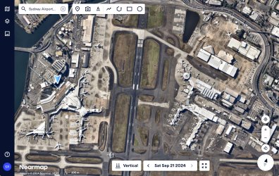
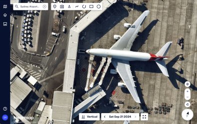
Google Maps and Google Earth are “so yesterday” 🥱. The cool kids use NearMap. The images are taken regularly from overhead planes. The resolution is much better than satélites and measurements can be made from the images.

The below was taken a week ago.
IMG_2854.jpeg

IMG_2855.jpeg

I don’t know Sydney airport that well, but if there’s a particular location and date you’re looking for, let me know.
 
For a fee

It was free in the early years and is now around 2k per annum depending on how much it’s used. It’s marketed towards business. We pay for it because it’s cheaper than visiting a worksite.

I think there is a free licence for non profits and educational purposes.
 
free licence for non profits and educational purposes.
Strictly controlled - need letter to confirm association with these organisations.
I know my Local council uses them. Had a council person say that a tree dissapeared from one of my paddocks and some of the trees were dead. Google map imagery predates the tree "dissapearing" He said council uses nearmap. I had a photo of the fallen tree luckily.

Our local council in Victoria uses it to ping people for unregistered pools and spas.
 
It was free in the early years and is now around 2k per annum depending on how much it’s used. It’s marketed towards business. We pay for it because it’s cheaper than visiting a worksite.

I think there is a free licence for non profits and educational purposes.
Oh handy to know, apparently I have access through work.
 
Why would that be of concern to the council?
Can't cut down a tree without council permission

We have a paddock over 100 trees
They could see from the tree canopy that there was a hole = tree no longer there. Dead tree = killed off by drill hole and roundup. So came around to investigate

Luckily we had a picture of fallen treee

We cant even cut down a bleached dead tree because it is habitat for various birds/koalas. But in the context of over 100 trees, why would a koala or bird want to sit in a dead tree when adjacent is a tree with healthy foliage and cover.....
Ive never seen a koala in the area . Its all subdivided acreage, too hard for koalas to move around
 
Google Maps and Google Earth are “so yesterday” 🥱. The cool kids use NearMap. The images are taken regularly from overhead planes. The resolution is much better than satélites and measurements can be made from the images.
This is what I was alluding to in my earlier posts - probably should have been more explicit that Google are obviously not using their own imagery for drawing maps! Yes, a plethora of imagery service providers now - on a user pays basis.
 
Can't cut down a tree without council permission

I live on the fringe of a small town. Some blocks around me being developed. Many with (fairly degraded) bushland on it.

Neighbour was allowed to completely clear-fell the entire block (c 1/2 acre) to make way for building a house. :)

I had a large eucalypt taken out that was growing too close to my house. No-one cared.

They could see from the tree canopy that there was a hole = tree no longer there. Dead tree = killed off by drill hole and roundup. So came around to investigate

They actually have time and inclination to look for gaps in canopies? Sheesh.
 
EXCLUSIVE OFFER - Offer expires: 20 Jan 2025

- Earn up to 200,000 bonus Velocity Points*
- Enjoy unlimited complimentary access to Priority Pass lounges worldwide
- Earn up to 3 Citi reward Points per dollar uncapped

*Terms And Conditions Apply

AFF Supporters can remove this and all advertisements

Become an AFF member!

Join Australian Frequent Flyer (AFF) for free and unlock insider tips, exclusive deals, and global meetups with 65,000+ frequent flyers.

AFF members can also access our Frequent Flyer Training courses, and upgrade to Fast-track your way to expert traveller status and unlock even more exclusive discounts!

AFF forum abbreviations

Wondering about Y, J or any of the other abbreviations used on our forum?

Check out our guide to common AFF acronyms & abbreviations.
Back
Top