Ask The Pilot

  • Thread starter Thread starter NM
  • Start date Start date
  • Featured
This was the reaction from a lot of the other crew. I never used to listen to the “expected” taxi route. It changed 99% of the time anyway.

Thankfully domestic is a lot better but you occasionally get the standard waffle that starts 100nm prior to top in CAVOK conditions.
Ask a question to start with. "Have you checked the STAR and approach in the FMC?". They should have, in which case virtually everything you could mention will have been covered. Make sure you're looking at the same approach and minima. Tell them how you're going to fly the approach and landing. Automatic or manual, or a mix. The most important items are the traps. LAX has a habit of hanging you up high and fast. How will you handle that. Go around, but only the unusual parts of it. For instance LAX and London the G/A may involve a continued descent at some stages of the approach.

ILS to 24L. The STAR is xyz. FMC's checked by everyone individually. Minima set. Low vis procedures, to a manual landing. Go around may be a descent to 2,000', in which case I will fly it using V/S and NAV modes. Autobrake set for exit at full length using BTV. Flap full, and full reverse thrust. Be aware of speed/height on base, the gear may be taken early. Ensure clearance before exiting runway. Brief done.
 
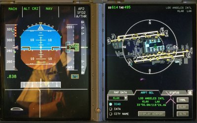
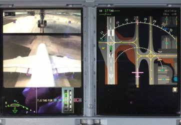
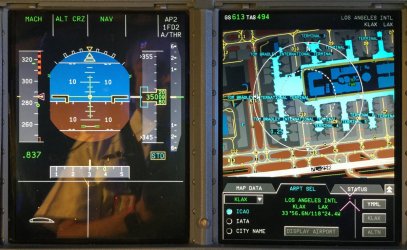
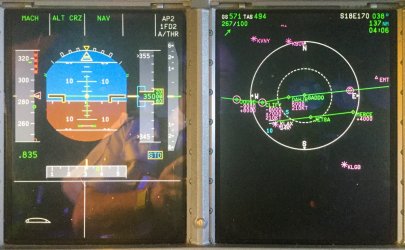
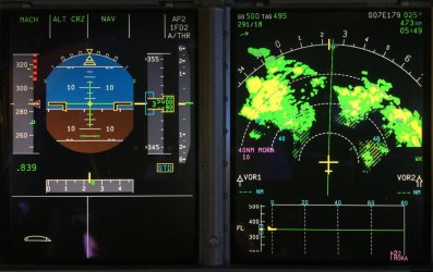
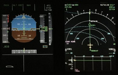
Some screen shots....
 

Attachments

  • IMG_0392.jpg
    IMG_0392.jpg
    180 KB · Views: 60
  • IMG_0427.jpg
    IMG_0427.jpg
    143.1 KB · Views: 60
  • IMG_0394.jpg
    IMG_0394.jpg
    196.6 KB · Views: 59
  • IMG_0397.jpg
    IMG_0397.jpg
    219.4 KB · Views: 56
  • IMG_0399.jpg
    IMG_0399.jpg
    192.5 KB · Views: 55
  • IMG_0416.jpg
    IMG_0416.jpg
    156.4 KB · Views: 55
  • IMG_0423.jpg
    IMG_0423.jpg
    142 KB · Views: 59
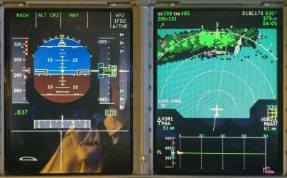
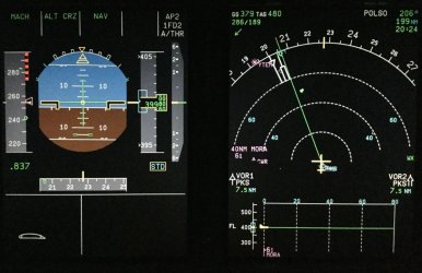
A windy day
The aircraft is on heading 206deg to POLSO 199nm away (near the NSW VIC border west of ABX), at FL400.
IAS 254kts, Mach 0.837 or True airspeed 480kts, Ground Speed 379kts
Green dot speed 241kts (??speed for best lift to drag ratio?)
Red dot bars = Vmax - maximum speed for the aircraft configuration depending on landing gear position and high lift config?

What's "286/189" ?wind direction from 289deg and wind speed 189 kts?

Currently over PKS and will get to POLSO in 20min 24sec?
 
Last edited:
The aircraft is on heading 206deg to POLSO 199nm away (near the NSW VIC border west of ABX), at FL400.
The heading is 227º. The track is 206º.
IAS 254kts, Mach 0.837 or True airspeed 480kts, Ground Speed 379kts
IAS is 254, but the target speed is a couple of knots faster ).
Green dot speed 241kts (??speed for best lift to drag ratio?)
Yep.
Red dot bars = Vmax - maximum speed for the aircraft configuration depending on landing gear position and high lift config?
Yes.
What's "286/189" ?wind direction from 289deg and wind speed 189 kts?
Wind direction and speed. So the wind speed is 350 kph.
Currently over PKS and will get to POLSO in 20min 24sec?
Try again. As you've said, POLSO is 199 nm away, and the ground speed is 379 knots; so it won't be happening in 20 minutes.

Whose sector is it, and how do you know? There are two clues. (There are really three, but the third is pretty vague).
 
Last edited:
EXCLUSIVE OFFER - Offer expires: 20 Jan 2025

- Earn up to 200,000 bonus Velocity Points*
- Enjoy unlimited complimentary access to Priority Pass lounges worldwide
- Earn up to 3 Citi reward Points per dollar uncapped

*Terms And Conditions Apply

AFF Supporters can remove this and all advertisements

Try again
Maybe ETA but not sure if Z time
ETA to waypoint?

Right seat pilot flying because :
1) AP2 causes the PFD to use right side pitot.
2)Also it’s on Autopilot with vertical mode holding at cruise altitude and lateral mode in NAV - to next waypoint. So not in descent.
3)Both flight directors active so redundancy is available

Target IAS is a couple kts faster because IAS is slightly below the triangle?
 
Last edited:
Maybe ETA but not sure if Z time
ETA to waypoint?
Z ETA at the next waypoint, at the current groundspeed. That could be a gotcha on descents, where your TAS would be changing dramatically. If ATC asked for crossing time, the reliable source was the FMC, not the nav display.
Right seat pilot flying because :
1) AP2 causes the PFD to use right side pitot.
2)Also it’s on Autopilot with vertical mode holding at cruise altitude and lateral mode in NAV - to next waypoint. So not in descent.
3)Both flight directors active so redundancy is available
AP2 means that the #2 autopilot is engaged, and autopilots were selected by side. Captain engaged 1, FO 2. So, it's the FO's sector.

The altitude is slightly off, which is also an indication that that altimeter is not being used by the autopilot. AP2 used the right hand system, as you stated.

The flight director is not quite centred, which indicates that the left FMC would like a slight correction...which it won't get, because the right FMC is the one currently being used by the autopilot.

1FD2 means that they are both flight directors are engaged. 1 on the left, 2 on the right.
Target IAS is a couple kts faster because IAS is slightly below the triangle?
You can also tell that the speed target is being generated by the FMC, because it's magenta. If you intervened, and selected a speed, it changed to a blue triangle.
 
Coming back to the 189kt crosswind.

How is that wind speed and direction deduced by the aircraft?.
Im speculating it is not measured but triangulated?

To do that 2 speeds and 1 angle is required. speed along Track (IAS), Speed along heading (??), angle between track and heading. (11 deg)

BTW how do you display the superscript "0" for degrees? in these pages.
 
Last edited:
Coming back to the 189kt crosswind.
How is that wind speed and direction deduced by the aircraft?.
Im speculating it is not measured but triangulated?

To do that 2 speeds and 1 angle is required. speed along Track (IAS), Speed along heading (??), angle between track and heading. (11 deg)
The FMC calculates with the following inputs. Heading, Track and groundspeed that come from the nav system and the TAS that comes from the air data computer.

The FMC then does a vector triangle calculation with the sides of the triangle being:

- Heading and TAS
- Track and groundspeed
- Wind direction and speed


BTW how do you display the superscript "0" for degrees? in these pages.
If you’re on an iphone it’s hidden under the 0. Hold your finger down on the number and it’ll pop up above it (°). Or do what JB does (much simpler - Thanks JB) Option + 0 on a Mac.
 
Last edited:
The FMC calculates with the following inputs. Heading, Track and groundspeed that come from the nav system and the TAS that comes from the air data computer.
And the FMCs have 3 inertial systems to get the groundspeed and track from.
If you’re on an iphone it’s hidden under the 0. Hold your finger down on the number and it’ll pop up above it (°). Or Shift + Option + 8 on a Mac.
And the one I use on a Mac, option 0.
 
The altitude is slightly off, which is also an indication that that altimeter is not being used by the autopilot

Why would the right side altimeter data be displayed slightly off any more than the left side?
Is it because there are 3 inertial reference units each measuring altitude but 2 are situated on left side?
 
Why would the right side altimeter data be displayed slightly off any more than the left side?
Is it because there are 3 inertial reference units each measuring altitude but 2 are situated on left side?
Altimetry is not an exact science. I forget the tolerances now, but it was something in the order of 20’ between left and right, and within 50 for the standby, during the preflight. Once you were flying, the tolerances were larger, with a scale of limits that varied with your altitude. I’ll look them up later. Inertial is not used for altitude measurement. GPS can be, and some failure modes would give us a display of GPS altitude, but it was pretty inaccurate. The altitude is measured purely by pressure readings from the static vents. It’s corrected by the air data computers for various known errors (for instance, temperature, or physical placement issues). So, when flying, the autopilot would put the altitude of the side it was using exactly at the target altitude. The other side of the aircraft would be showing whatever data it had, but virtually never would it be exactly the same. In the cruise the difference was around 50’, and the standby might be out by 200’.

Whilst we always talk about altitude, it’s worth remembering that aircraft do not actually fly altitudes with reference to the earth at all, unless they’re at relatively low levels. They actually fly at various atmospheric pressure levels (i.e. flight levels), and they equate to altitudes in a standard, homogenous atmosphere. The upshot is that a given flight level, and the aircraft flying at it, may wander up and down slightly as the conditions change. As all aircraft fly using the same pressure settings, this doesn’t affect separation, as all aircraft will be doing the same.
 
Last edited:
They actually fly at various atmospheric pressure levels
With reference to 29.92 inches of Mercury as the standard?.
Though when pilots talk with ATC , ATC informs pilots of airfield pressure reading which is often a slight variation to 29.92?

What would a change of 0.1 inHg do to actual altitude?
 
Stupid. And dangerous. There is very limited commonality, and nothing systems-wise.
That being the case, how have they got this through, and what will be the main “gotchas” for the pilots?

Noting aircraft ferrying companies often have pilots cross rated against a multitude of aircraft, airbus and Boeing and more, is this any different?
 
That being the case, how have they got this through, and what will be the main “gotchas” for the pilots?
It wouldn't be the first time regulators have allowed something that's poor, simply because the airlines wanted it.
Noting aircraft ferrying companies often have pilots cross rated against a multitude of aircraft, airbus and Boeing and more, is this any different?
If you lower the standard enough, you can do anything. Mind you, in the world of flying on the autopilot all of the time, and never actually being allowed to think, because there is a rule against it, it may be the new normal.
 
With reference to 29.92 inches of Mercury as the standard?.
Though when pilots talk with ATC , ATC informs pilots of airfield pressure reading which is often a slight variation to 29.92?

What would a change of 0.1 inHg do to actual altitude?
29.92 in Hg, is equal to the metric 1013.25 millibars. The USofA is about the only place using 29.92; that I operated to anyway.

A sea level pressure of 1013.25 mb, at 15ºC is the 'standard' atmosphere that everything is based on. When you transition from altitude to flight levels, you change from whatever the local pressure setting was, to 1013, and you'll use that all the way to your descent, where you'll transition back at some point to the local setting.

The altitude that ATC give us is normally QNH, which is the pressure setting that will cause an altimeter to give the height above sea level when at the aerodrome reference point. QFE is another setting, used in some parts of the world that causes the altimeter to read zero at that reference point. For pretty obvious reasons, you don't want to get them mixed up. We never used QFE.

A change of one millibar equates to 27', so you can do the maths to work out .1 in Hg.
 

Become an AFF member!

Join Australian Frequent Flyer (AFF) for free and unlock insider tips, exclusive deals, and global meetups with 65,000+ frequent flyers.

AFF members can also access our Frequent Flyer Training courses, and upgrade to Fast-track your way to expert traveller status and unlock even more exclusive discounts!

AFF forum abbreviations

Wondering about Y, J or any of the other abbreviations used on our forum?

Check out our guide to common AFF acronyms & abbreviations.
Back
Top