New MH370 search aircraft investigation

marki

Established Member
Joined
Feb 11, 2010
Posts
3,437
Qantas
Platinum 1
Virgin
Gold
Oneworld
Emerald
SkyTeam
Elite
Star Alliance
Silver
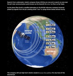
Malaysia Airlines Flight 370 (MH370) disappeared on March 8, 2014, during a flight from Kuala Lumpur to Beijing with 239 people on board. The last communication was 38 minutes after takeoff, after which the plane deviated from its planned route, last tracked by military radar over the Andaman Sea. Subsequent satellite data from Inmarsat suggested the plane continued flying into the southern Indian Ocean, leading to extensive searches in that region.

Despite vast search efforts, no definitive wreckage was found until debris, confirmed from MH370, washed up on shores like Reunion Island and the East African coast. Theories abound, from mechanical failures to deliberate action by the pilot, but no conclusive cause has been established. The mystery persists, with occasional new searches proposed, but the fate of MH370 and those aboard remains one of aviation's greatest mysteries.

 
Solution
Do you understand how satellite imagery works? For bonus points, name a satellite currently conducting staring ops or imagery collection of a large, uninhabited water space and who is paying for that?
Hi Scarlett,

Far be it for me to be an expert on satellites - I am not Elon Musk - but I believe - A Satellite Conducting Staring Ops or Imagery Collection would be several notable satellites for staring operations or prolonged observation of large uninhabited water spaces but one would be Jason-3.
It's part of a series of satellites dedicated to observing ocean topography for oceanography and climate studies. Jason-3, operated by NASA (National Aeronautics and Space Administration), NOAA (National Oceanic and Atmospheric...
1736799991631.png
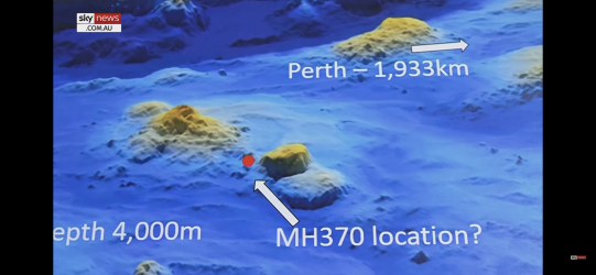
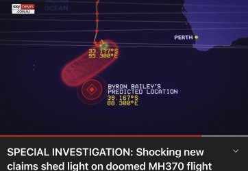
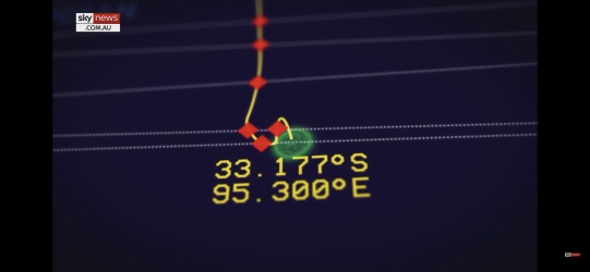
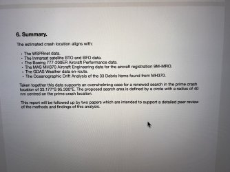
Below is Approx by Pilot Byron Bailey - I flew with him !! 1736801002080.jpeg
1736800124168.png
EVERYTHING ON AN AIRPLANE IS MADE TO FLOAT!

This right here should raise the questions. How was there NO debris ( immediately after ) ? No seats no piece of the aircraft. No ones backpack. NOTHING. NOT EVEN A DAMN EMTPY CUP.
 
Read our AFF credit card guides and start earning more points now.

AFF Supporters can remove this and all advertisements

Interesting Geoff Thomas from WA implies the aircraft did shatter on impact so is not intact but in pieces.
 
>> EVERYTHING ON AN AIRPLANE IS MADE TO FLOAT!

It doesn’t matter if there were some objects floating (debris field) for the first 24 or even 48 hours, if no one is looking anywhere near the site. 🙄
 
I wouldn’t go to any effort in quoting Sky News on anything, let alone missing aircraft.
Sky news has the best News program in Australia,. Yes I get that a lot of you don't like the commentators they have at night but forget that and watch their news. Keiran Gilbert is way ahead of most news presenters on Australian TV. The only person better is on the ABC as Insiders host and that is David Speers who of course worked at Sky News for nearly 19 years winning many awards whilst working at Sky.
 
Sky news has the best News program in Australia,. Yes I get that a lot of you don't like the commentators they have at night but forget that and watch their news. Keiran Gilbert is way ahead of most news presenters on Australian TV. The only person better is on the ABC as Insiders host and that is David Speers who of course worked at Sky News for nearly 19 years winning many awards whilst working at Sky.
Horses for courses, I suppose.

Away from Oz news services, some people like Fox8, but others prefer CNN.
 
>> EVERYTHING ON AN AIRPLANE IS MADE TO FLOAT!

It doesn’t matter if there were some objects floating (debris field) for the first 24 or even 48 hours, if no one is looking anywhere near the site. 🙄
Yes, it is a tiny little fact; however, it is overlooked that footage of the satellite images is available to be looked at in retrospect.:)
 
Last edited:
Last edited:
Exactly. No-one knows where it went down. 🤷‍♂️
Well, some have had a go at trying to explain it and make good points. The debris found so far mainly excludes a soft, controlled landing in the Southern Ocean—Captain Byron Bailey's Favourite explanation.
 
[Moderator hat]

This thread had wandered off topic.​
Check the title and post accordingly, those who fail to do so may be subject to further sanction.​
[/Moderator Hat]
 
Yes, it is a tiny little fact; however, it is overlooked that footage of the satellite images is available to be looked at in retrospect.:)
Do you understand how satellite imagery works? For bonus points, name a satellite currently conducting staring ops or imagery collection of a large, uninhabited water space and who is paying for that?
 
Do you understand how satellite imagery works? For bonus points, name a satellite currently conducting staring ops or imagery collection of a large, uninhabited water space and who is paying for that?
Hi Scarlett,

Far be it for me to be an expert on satellites - I am not Elon Musk - but I believe - A Satellite Conducting Staring Ops or Imagery Collection would be several notable satellites for staring operations or prolonged observation of large uninhabited water spaces but one would be Jason-3.
It's part of a series of satellites dedicated to observing ocean topography for oceanography and climate studies. Jason-3, operated by NASA (National Aeronautics and Space Administration), NOAA (National Oceanic and Atmospheric Administration), EUMETSAT (European Organisation for the Exploitation of Meteorological Satellites), and CNES (Centre National d'Etudes Spatiales, the French space agency), collects data on sea surface height which can infer ocean currents, wind speed, and marine weather. Funding for such missions typically comes from these international collaborations, with each agency contributing to the project costs.

I remember being shown satellite images of those areas vast empty ocean. I learn every day because if I don't learn, I don't or won’t progress.
So, the Answer to your question and MH370 staring operations, and bonus points!

Yes, satellite imagery was indeed utilised in the search for Malaysia Airlines Flight MH370. After the plane went missing on March 8, 2014, various countries deployed their satellite assets to scan the possible crash areas.

  • Optical Satellites: Satellites like WorldView (operated by DigitalGlobe, now Maxar Technologies) and Gaofen (Chinese satellite) were used to capture images where debris might be visible. However, these require good weather conditions and daylight.
  • Radar Satellites: The German TerraSAR-X, operated by the German Aerospace Center (DLR), and the French Pleiades, used for high-resolution imagery, were also employed. These could "see" through clouds, providing images when optical satellites could not. :)
 
Last edited:
Solution

Become an AFF member!

Join Australian Frequent Flyer (AFF) for free and unlock insider tips, exclusive deals, and global meetups with 65,000+ frequent flyers.

AFF members can also access our Frequent Flyer Training courses, and upgrade to Fast-track your way to expert traveller status and unlock even more exclusive discounts!

AFF forum abbreviations

Wondering about Y, J or any of the other abbreviations used on our forum?

Check out our guide to common AFF acronyms & abbreviations.
Back
Top