


Kefci2000
Established Member
- Joined
- Apr 3, 2010
- Posts
- 1,244
- Qantas
- Platinum
- Virgin
- Platinum
- Oneworld
- Emerald
- SkyTeam
- Elite
Waiver Policies
Qantas:
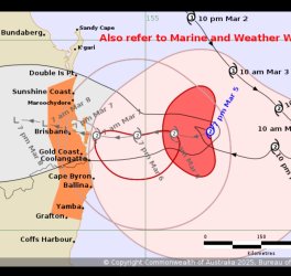
Bureau of Meterology - Cyclone Alfred
Latest forecast track:


Qantas:
Virgin Australia:
JetStar:
Bureau of Meterology - Cyclone Alfred
Latest forecast track:
Attachments
Last edited by a moderator: