Midair collision between Helicopter and CRJ (AA5342) at Washington (DCA)

For helicopter pilots:

What is the error range of altimeters?.
X00feet indicated = X 00 feet +/- actual?

How easy is it to maintain altitude at X?. Is there an allowed variability?
Altimeters for helicopters typically have an error range of **±50 to ±100 feet** under normal conditions, meaning an indicated altitude of X00 feet could be X00 ±50-100 feet. Maintaining altitude is challenging due to helicopter instability, but pilots generally aim to stay within **±100 feet** of their target altitude, with tighter tolerances in instrument flight. Environmental factors and pilot skills significantly influence precision. NVGs can give altered height perception as well.
 
Last edited:
Helicopter or fixed wing it’s fair to say they are the same ie highly accurate, but they require accurate local air pressure data which is why QNH is always mentioned. If the pilot does not have the right QNH dialled in, you get errors ….
I agree with Markis10 above; altimeters in helicopters and fixed-wing aircraft are highly accurate but depend on correct QNH (local air pressure) settings. If the pilot dials in the wrong QNH, the altitude reading will be inaccurate, emphasizing the need for precise QNH updates from ATC to ensure safe operations. How many times has this gone in the other direction, however? Some maps are outdated, and the topography will also be. To make the alarm go away (PULL up), the pilot zeros the QNH. Therefore, annoying alarm distractions will be silenced until CFIT is too late.
 
NTSB reporting CRJ altitude (from FDR plus or combined withADS-B) to be 325Ft +/- 25ft close to point of collision.

So I come back to the question: how easy is it for a helicopter like this one to maintain 200ft altitude while flying - assuming manually operated flight and at night using NVG?
 
Last edited:
EXCLUSIVE OFFER - Offer expires: 20 Feb 2025

- Earn up to 200,000 bonus Velocity Points*
- Enjoy unlimited complimentary access to Priority Pass lounges worldwide
- Earn up to 3 Citi reward Points per dollar uncapped

*Terms And Conditions Apply

AFF Supporters can remove this and all advertisements

I agree with Markis10 above; altimeters in helicopters and fixed-wing aircraft are highly accurate but depend on correct QNH (local air pressure) settings. If the pilot dials in the wrong QNH, the altitude reading will be inaccurate, emphasizing the need for precise QNH updates from ATC to ensure safe operations. How many times has this gone in the other direction, however? Some maps are outdated, and the topography will also be. To make the alarm go away (PULL up), the pilot zeros the QNH. Therefore, annoying alarm distractions will be silenced until CFIT is too late.
Any need to shout it in bold?
 
Any need to shout it in bold?
By the looks of it, the intention was supposed to be the other way around, a simple mistake, I guess, easy enough to do.

i.e., "I agree with Markis10 above; "people can be way too sensitive to such minor transgression nowadays. Sign of the times? Cough cough; I am no slouch when it comes to transgressions either. I agree with Markis10 as well because the slip of the fingers can be so devastating in these circumstances.
 
Last edited:
I agree with Markis10 above; altimeters in helicopters and fixed-wing aircraft are highly accurate but depend on correct QNH (local air pressure) settings. If the pilot dials in the wrong QNH, the altitude reading will be inaccurate, emphasizing the need for precise QNH updates from ATC to ensure safe operations. How many times has this gone in the other direction, however? Some maps are outdated, and the topography will also be. To make the alarm go away (PULL up), the pilot zeros the QNH. Therefore, annoying alarm distractions will be silenced until CFIT is too late.
When you’re low flying, you rely on the radar altimeter. Any form of pull up warning is also radar based. I have no idea what you’re talking about with regard to zeroing a QNH to make a warning go away.
 
NTSB reporting CRJ altitude (from FDR plus or combined withADS-B) to be 325Ft +/- 25ft close to point of collision.

So I come back to the question: how easy is it for a helicopter like this one to maintain 200ft altitude while flying - assuming manually operated flight and at night using NVG?
It should be relatively easy. Helicopters are basically slow, and 200’ is high. These are army pilots…10 feet is the sort of flying they would do in some circumstances, albeit not at night. Even if they were above the height they should have been at, the separation is woefully inadequate. I think it will take them a while to get there, but this all comes back to ATC in the USA being terribly broken. It has been for many years, and I doubt that it’s going to change.
 
Last edited:
Altimeters for helicopters typically have an error range of **±50 to ±100 feet** under normal conditions, meaning an indicated altitude of X00 feet could be X00 ±50-100 feet. Maintaining altitude is challenging due to helicopter instability, but pilots generally aim to stay within **±100 feet** of their target altitude, with tighter tolerances in instrument flight. Environmental factors and pilot skills significantly influence precision. NVGs can give altered height perception as well.
I am interested to know where/how you surmise this or where you got the information from?

I cannot think of any circumstance where a helicopter could not hold accurate altitude to any degree less than a fixed wing aircraft.
 
It should be relatively easy. Helicopters are basically slow, and 200’ is high. These are army pilots…10 feet is the sort of flying they would do in some circumstances, albeit not at night. Even if they were above the height they should have been at, the separation is woefully inadequate. I think it will take them a while to get there, but this all comes back to ATC in the USA being terribly broken. I has been for many years, and I doubt that it’s going to change.

I can pretty much guarantee this is not supposed to be procedurally separated (ie the ability to set and forget) - it relies on visual separation from either the pilot or ATC. If that can't be done then the helicopter holds at a point clear of final until the path is clear - and that's probably why they have a dedicated helicopter controller.

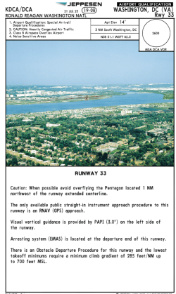
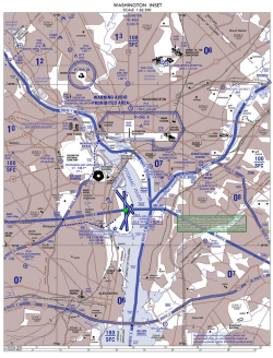
There's also nothing stopping the CRJ descending to 200FT if it wants to. I looked up the Jeppesen charts for DCA and the helicopter route isn't even mentioned. I would have thought it deserved a mention here:

1738540039298.png
 
the separation is woefully inadequate
Generally a 'system" design should account for potential and forseeable errors/threats whether machine or human.
In this case there appears to be no vertical separation built into the system
While there would be lessons out of this for every stakeholder, I suspect the major corrections will need to start at the Congress / FAA rather than just ATC

I looked up the Jeppesen charts for DCA and the helicopter route isn't even mentioned
Where i I find the Class Bravo maps for DCA?

I cannot think of any circumstance where a helicopter could not hold accurate altitude to any degree less than a fixed wing aircraft.
Would you say easier than Fixed wing?
 
When you’re low-flying, you rely on the radar altimeter. Any form of pull-up warning is also radar-based. I have no idea what you’re talking about about zeroing a QNH to make a warning go away.
Ah yes it common in the military especially Europe. I can explain a little - there are well know examples on You Tube. =>Under air crash investigation there are good examples of zeroing of QNH. So on reset of the QNH - causes the altitude to rise. To its default QNH. More to do with out dated maps near military airports, because Jeppson(civilian) charts wont have that kind of specific data. For obvious reasons - certainly map data in Russia is usually hard to come by ( truely accurate data) And looking at radar24 Russian/Ukraine airspace is avoided!
 
Last edited:
The initial suggestion was that the helo was reporting 200ft to the ATC displays (preliminary, to be confirmed)

Close but combined with the ATC instruction to cross behind the aircraft, possibly looked OK.

Hence the discussion in the last few pages on QNH settings or anything else that could alter reported altitude.

Swiss cheese and all that.
 

Become an AFF member!

Join Australian Frequent Flyer (AFF) for free and unlock insider tips, exclusive deals, and global meetups with 65,000+ frequent flyers.

AFF members can also access our Frequent Flyer Training courses, and upgrade to Fast-track your way to expert traveller status and unlock even more exclusive discounts!

AFF forum abbreviations

Wondering about Y, J or any of the other abbreviations used on our forum?

Check out our guide to common AFF acronyms & abbreviations.
Back
Top